|
Traffic
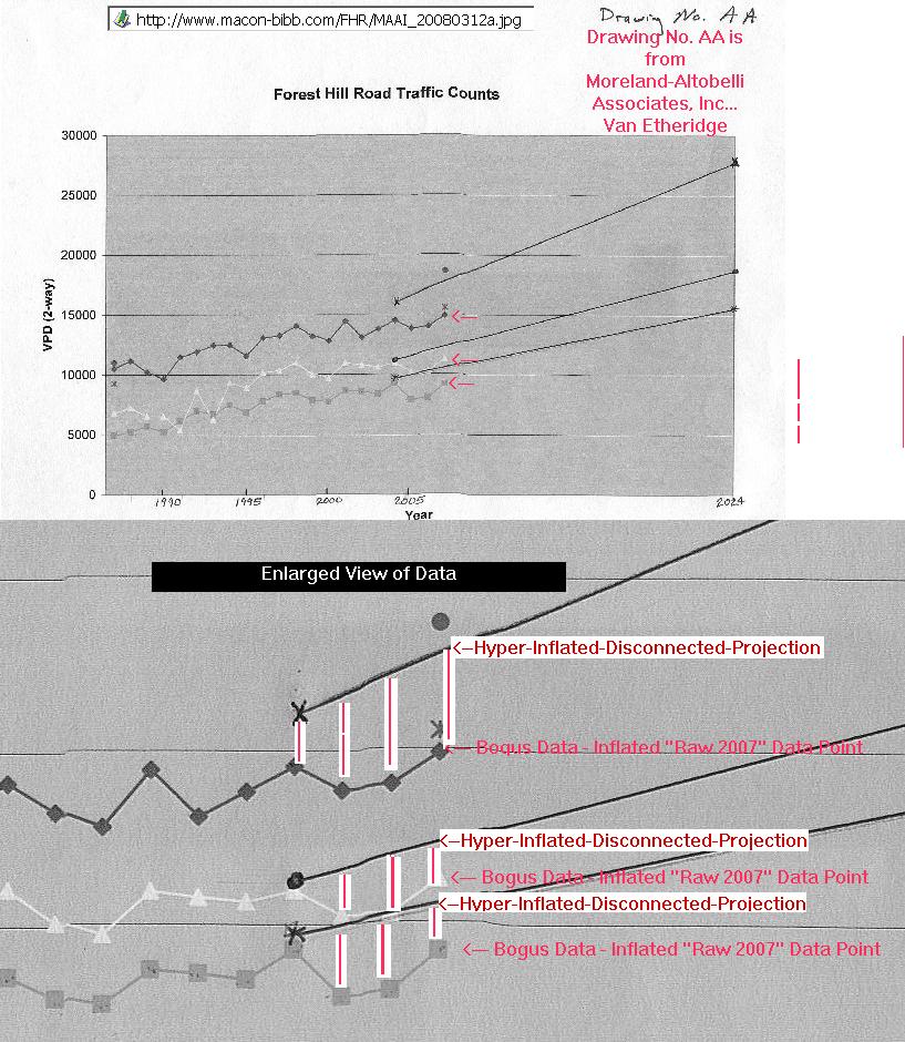
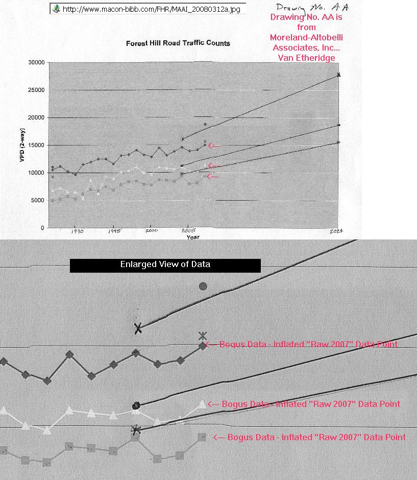
Counts used to justify FHR are grossly exaggerated.
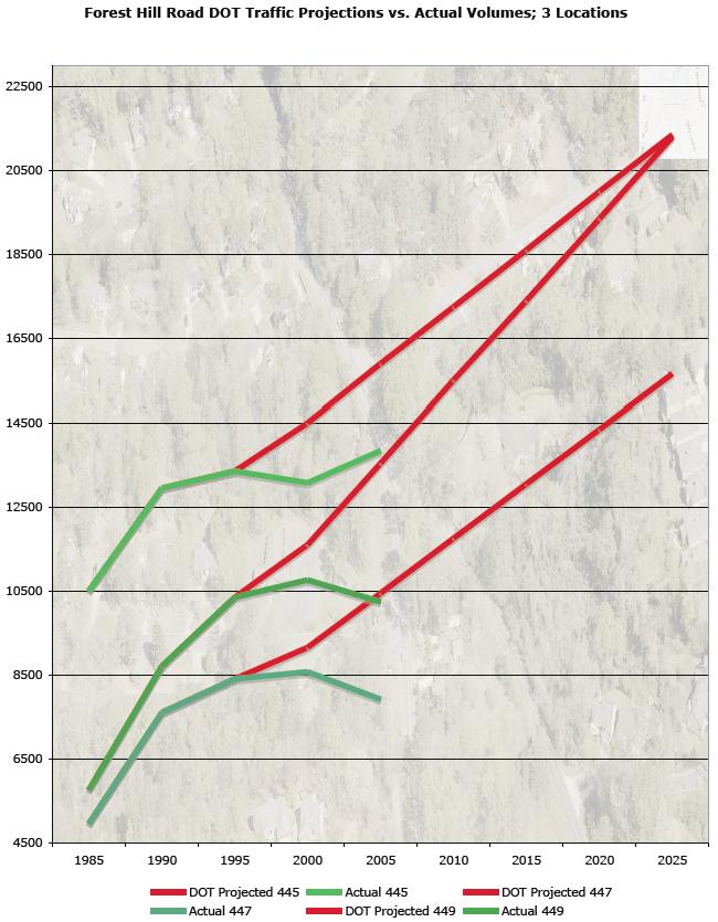
- Counts have been relatively flat for past
20 years (see chart below)
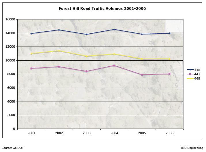
- Realistic
traffic projections would not require or justify a design of this scale
and cost.
- The
FHR project was originally justified as a road to the Macon Mall. It
would feed a new “Northwest Parkway” offering a convenient shortcut
to the mall from north Macon. The Macon Mall is now on the
decline, the Northwest Parkway is no longer under active consideration,
but FHR is still projected to handle more than double its current load,
despite flat traffic counts for the past 20 years.
- Vineville Avenue, the primary roadway fed by FHR,
lacks additional capacity (90% of the traffic from southbound FHR will
continue on Vineville Avenue according to RIP projections).
- No
plans for expansion of Vineville, which traverses locally valued
historic districts, have been approved.
- The
cumulative growth rate for Macon is projected by the Macon-Bibb
Planning & Zoning Department to be a total of 4% between now and
2035.
Constraints
on FHR capacity are and will remain the intersections.
- Rush
hour congestion on FHR is due entirely to constraints at the major
intersections (Vineville, Ridge, Wimbish and Northside).
- Intersection
improvements, including better turning movements and additional
stacking, would redress this problem to the extent possible; these
intersections, particularly that with Vineville, will remain the constraint on FHR’s carrying
capacity.
- The
intersections can, however, be improved at reasonable cost without
expansion of the intervening roadway and without sacrificing local
utility or the integrity and safety of adjacent neighborhoods.
- The
benefits to improved traffic flow and safety will be equal to that of
the proposed project, at a savings to taxpayers of approximately $30
million dollars.
Public Safety is
compromised by the proposed design.
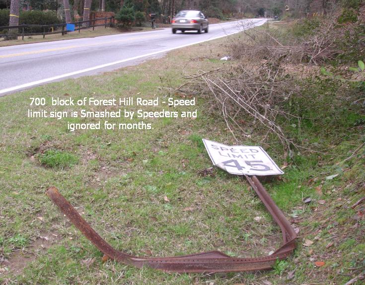
- The design speed of the FHR project is
47mph; the posted speed will be 35mph.
 - MAAI
representatives have acknowledged that “after build” reviews are not
conducted as a way of verifying project assumptions and projections.
Such evidence-based reviews would show that several RIP projects have
significant problems due to scale and excessive design speeds.
- Mr. Chellman, an international renowned
traffic engineer/planner hired by the residents of FHR, has suggested
combining and reconfiguring the Northminster/Wimbish
intersection with the Wimbish/Forest Hills Roads intersection to
remedy a major safety problem. The proposed plan
moves the Northminster intersection and conflicts further east at
significant cost, but does not remedy them. There is heavy school
traffic on Northminster during the morning rush hour
The scale
of the project is unnecessarily expensive and intrusive.
- The separated four-lane configuration of
the Wimbish to Ridge segment of FHR is of a scale without precedent in Bibb
County for even
the exaggerated traffic volumes cited for FHR.
- The width is comparable to that of the
newly completed section of Riverside Drive
and Forsyth Road,
both of which are major arterials. The design is
inappropriate for an existing residential neighborhood (modern traffic
planning standards require “context-sensitive design”).
- The design denies safe and convenient
access to adjacent residential properties and to St. Francis Church.
The
excessive cost of the project does not result in comparable value.
- The local utility of FHR will be reduced.
- Safety will be compromised.
- Capacity will be increased only by the
improvements to major intersections, not by the excessive scale of the
intervening roadway.
- Future maintenance and policing costs
will be excessive.
City Council and Residents
concerns have been ignored.
The City Council
has passed several resolutions requesting a more appropriate and
neighborhood friendly design (numbers/dates).
http://www.macon-bibb.com/FHR/MaconCouncilResolutionPower.htm
The City's concerns have been ignored.
Residents have
presented these concerns prior to and during the planning process;
these concerns have not been addressed. Please see the
Position Paper, below, dated 2-25-2008.
|
|
|
Citizens
Position Paper
Citizens have formulated “Design criteria and Constraints” that we
believe should guide design of the FHR Project and mediation, and which
address the neighborhoods’ primary concerns – footprint, speed, access,
neighborhood integrity, and drainage:
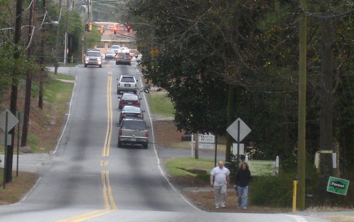
• Protect the integrity and livability of neighborhoods fronting and
served by Forest Hill Road.
• Recognize Forest Hill Road as one of Macon’s premiere scenic
residential roadways, and protect that asset.
• Provide for the safety of motorists, pedestrians and school children.
• Provide safe and convenience access to adjacent businesses, churches,
schools, and residential areas.
• Provide unimpeded access by public safety vehicles.
• Minimize on-going maintenance and operations costs by the City of
Macon and Bibb County, to include traffic control, storm drainage and
policing costs.
• Use modern traffic-calming and neighborhood-sensitive design
techniques to further the all of above.
• Employ a design speed of 35mph.
• Minimize the footprint of the roadway and construction zone to
preserve the existing landscaping and tree cover, and to avoid the
expense and disruption of relocating utility lines and poles and
channelizing storm drainage.
• Recognize that the current Statement of Need is outdated, and adopt a
new one that realistically reflects current and future needs and
traffic volumes.
• Thoroughly study the effect of induced traffic volumes on
Vineville/Forsyth, Ridge, and Park Street; delay construction if
increased volume will require expansion of those roadways that is
unmanageable, unacceptable, or not contained in approved projects
scheduled for completion in the immediate future.
• Protect the historic resources at Park Street, the Prado and the
residences along FHR.
|
|